We can recognize what is our position by using a GPS instrument at any where in the world. The GPS give its position from satellite signals. There are 24 satellites in 6 inclined orbits only for this propose

If GPS instrument can know accurate distance from three satellites it can give what is its position. For example from distance A, B, C satellites to our GPS is X, Y, Z. the A, B, C satellites are known orbits (that means the GPS know what is the position with time). So there is only one point which from distance A, B, C satellites to our GPS comes X, Y, Z at a time.
 As above Figuer only one point which intersect X, Y, Z distance from 3 satellites at movement. But above (Fig) is in 2D because it is difficult to show 3D figure. But actually they are in 3 dimensional, so above possible distance are spheres (in 2 dimensional 2 satellites are enough to identify a point). The GPS measure distance to satellites by time take for come to GPS from satellites. But satellite signals are electro magnetic waves so they travel l86000 miles per second. So time should be very accurate. So satellites have atomic clocks for make that accurate time. The atomic clock has 10-9 second accurate. And GPS measure distance as below
Distance = time takes to reach to GPS from satellite * speed of electro magnetic waves
Satellites transmit their signals with time plus as below

The GPS synchronize with the Satellites and generate time plus like above. Cause GPS instruments have not atomic clocks. When GPS receive a signal, first mach it with GPS time plus and measure the time takes to reach as below.
 Signal receive from all satellites are mach like above then it measure the distances. Show the coordinates by using its memory. That is the action of a GPS simply. But there are so many complex processes in take position from a GPS.
There are so many errors for effect to GPS position like
• Ionospheric errors
When signal receive from satellite, they had to come through the Ionosphere. The Ionosphere is effect to the radio signal.
• Multipath errors
Same signals come to GPS from various paths like bounces from buildings.
• Errors in GPS
Error GPS gives wrong data
• Errors in satellite
Some times satellite also can have some errors. So they are daily update.
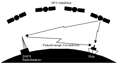
To minimize these errors people use Different ional Global position system (DGPS). In DGPS we use two GPS. One GPS we keep as a reference one at a location of known accurately surveyed point. And other is use to do other survey or any work. The error of the reference GPS is transfer to other GPS by radio signal or any other way. The cause is two GPS has same errors at same time, because satellite are at 20200 km altitude so we can assume the two GPS are at same position and errors are same. And we know one GPS position accurately so we can measure the error and transmit it to other GPS.

This project has a mathematical module, so it wants start and end points accurately. They should give by coordinates so we want GPS for it, and when we go to field we should identify our start and end point, we want a GPS for it. Using rough coordinate taken from satellite image we can identify them.
After refer the area where going to do the evaluation and identifying the start and end point of the area, its better to learn about the Sri Lanka coastline, like how it form why some areas still eroding and some areas not.

No comments:
Post a Comment